Page 1 of 1
(SW–N) (N–NE) (NE–S) = ??
Posted: Sat Aug 19, 2017 9:42 am
by luckyb52
Hi All,
When studying the chart supplement for KSBD, I saw the following:
SOCAL APP/DEP CON 125.5 (SW–N) 127.0 (N–NE) 134.0 (NE–S) 135.4 (S–SW).
What do (SW–N), (N–NE) etc mean?
Thanks in advance for the answer!!!
Best
Lucky 
///////////
Re: (SW–N) (N–NE) (NE–S) = ??
Posted: Sat Aug 19, 2017 10:39 am
by kullery
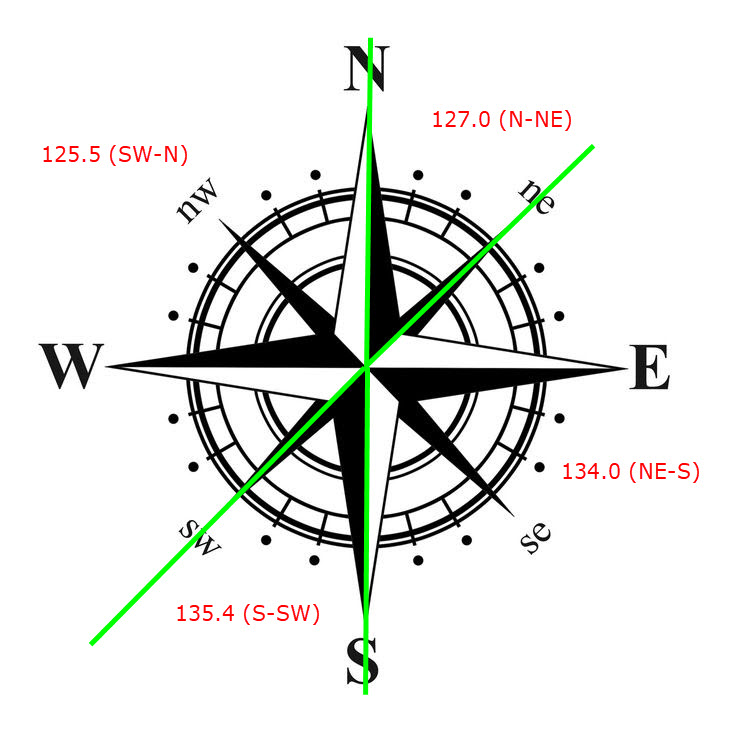
- Compass-Rose.jpg (86.2 KiB) Viewed 2980 times
Re: (SW–N) (N–NE) (NE–S) = ??
Posted: Sat Aug 19, 2017 6:39 pm
by luckyb52
Thanks, that's what I thought too, but that was until I read in the
CAT 7 page that for a westward flight path to El Monte, we are supposed to contact SoCal Approach on 127.0, which according to the chart supplement is for N-NE.
Why is the N-NE frequency used for a westward journey??
Best,
Lucky
Re: (SW–N) (N–NE) (NE–S) = ??
Posted: Sat Aug 19, 2017 11:15 pm
by kullery
For example looking at our route of flight from KSBD to KEMT you would see that to transition the KONT Class C airspace from the North East you would contact SOCAL approach on 127.00.
The above is with reference to making a transition of the KONT airspace. For
KONT the chart supplement shows the following:
SOCAL APP/DEP CON 125.5 (SW–N) 127.0 (N–NE) 134.0 (NE–S) 135.4 (S–SW)
Re: (SW–N) (N–NE) (NE–S) = ??
Posted: Sun Aug 20, 2017 3:05 am
by luckyb52
Thanks Kullery, my bad... I missed that sentence on the CAT 7 page.
Best
Lucky