The iPad-Challenged PE Newbies Guide to ForeFlight

Calvin Waterbury
Posts: 199
Joined: Mon Nov 07, 2011 10:37 am

Re: The iPad-Challenged PE Newbies Guide to ForeFlight

Post by Calvin Waterbury »

arb65912 wrote:Calvin, I was reading about Simplates but I have never run of anything updates, charts change, what is the option there? Cheers, AJ
Hi AJ,

I have only tested a small sample, mainly of ZLA and KACT, but I have been surprised to discover everything I have seen so far has been in the current cycle! I will be glad to check out any charts you like to see if they are current. :)

Frankly, I wasn't surprised to see the likes of KLAX, KSNA, etc. were updated, but I was when I saw the charts for lowly Waco, TX were up to date! :o

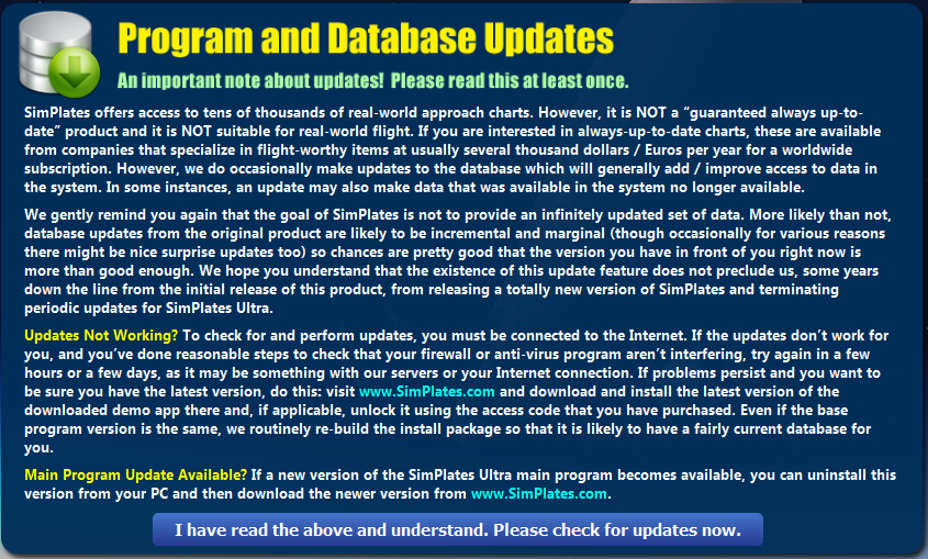
Here is a screenie of the update policy inside the software...

Image

Ciao!
Last edited by Calvin Waterbury on Wed Feb 06, 2013 7:12 am, edited 2 times in total.
Windows 8.1 (64)
ASUS 17" Laptop
2.4 GHz I7-4700HQ CPU
8 GB RAM
NVIDIA GeForce GTX 860M
1 TB HDD
arb65912
Posts: 646
Joined: Sun Jul 17, 2011 5:40 am
Contact:

Re: The iPad-Challenged PE Newbies Guide to ForeFlight

Post by arb65912 »

Hi Calvin, thank you for the reply, the reason I asked is that since you download the software ( which is probably pretty up to date) and use it off line, no further updates are done.
I was thinking about the plates more for international flying on VATSIM , that is why I asked. Thank you again, Calvin. Cheers, AJ
Tim Krajcar
Posts: 503
Joined: Mon Jan 24, 2011 11:41 am
Location: KPDX
Contact:

Re: The iPad-Challenged PE Newbies Guide to ForeFlight

Post by Tim Krajcar »

Calvin Waterbury wrote:Frankly, I wasn't surprised to see the likes of KLAX, KSNA, etc. were updated, but I was when I saw the charts for lowly Waco, TX were up to date! :o
US charts are published for free in easily machine-digestable formats by NACO, so it's not surprising that they have coverage for all of the US.

What becomes much more challenging is world-wide coverage. The DoD and the relatively new National Geospatial-Intelligent Agency once published DAFIF, complete charts and aeronautical navigation data (VOR & fix locations & frequency, airways, etc) in both paper and electronic format, but in 2006 they restricted access to this wonderful datasource to DoD and government agencies only. So, accessing charts for other regions of the world can be very challenging - some countries/organizations require you to be a registered pilot within that country, or charge fairly large sums of money for access to charts (even electronic-only access).

The FAA/NACO has made noise about charging for US chart access in the past as well. Write your congressman ;)
Tim Krajcar
Live streams at http://twitch.tv/Tim_PE
View past flights on YouTube
Alex Stjepanovic
Posts: 1752
Joined: Wed Oct 06, 2010 3:48 pm
Location: Novi Sad, Serbia

Re: The iPad-Challenged PE Newbies Guide to ForeFlight

Post by Alex Stjepanovic »

There are still very much public/legal/unprotected sources of updated DAFIF, and similar data still around. One just has to know how and where to look for them ;)
Post Reply