Page 1 of 1
Question about KNYL ILS or LOC 21R
Posted: Sun Aug 10, 2014 8:23 am
by C177pilot
The NYL NavAid is a TACAN. So in a civilian A/C how does one identify the FAF since it's is 6.9 DME from NYL? Does this mean Radar service is required? I don't see that noted. Practically I could use the GPS, but I don't know how to identify the FAF any other way.
I'm just now working on my instrument rating, so this may be a dumb question. But I'll learn something I don't currently know at least.
Thanks,
Chris
Re: Question about KNYL ILS or LOC 21R
Posted: Sun Aug 10, 2014 9:24 am
by Ryan B
It has DME though on 113.70 - which you should be able to tune.
Re: Question about KNYL ILS or LOC 21R
Posted: Sun Aug 10, 2014 10:32 am
by C177pilot
How do you know this from the chart. I found it on a cross reference table but the chart does not have that info that I can find.
Re: Question about KNYL ILS or LOC 21R
Posted: Sun Aug 10, 2014 11:53 am
by Ryan B
It's on the low alt enroute sectional chart (use skyvector)
But I agree it's not on the IAP. I guess the keyword if you're not using the ILS is "LOC/DME" Plus if you were flying there in real life IFR you'd probably have a low alt chart handy (or foreflight/EFB etc)
Re: Question about KNYL ILS or LOC 21R
Posted: Mon Aug 11, 2014 7:45 am
by Keith Smith
I flew this during one my my Twitch streams a few months ago and ran into the same issue. It took a while to realize it was on the low enroute but not on the approach plate.
Re: Question about KNYL ILS or LOC 21R
Posted: Fri Aug 22, 2014 9:15 am
by kullery
I don't think that this is an issue with the LOC/DME RWY 21R approach plate but is instead a problem with the X-plane database (Resources\default data\earth_nav.dat).
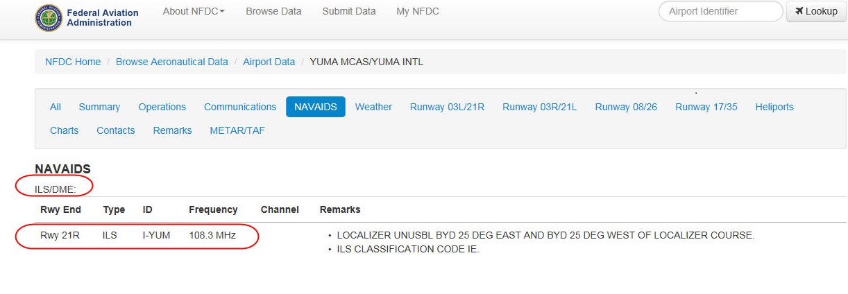
Per the
NFDC, I-YUM (on 108.3)
is DME enabled however it is not enabled in X-plane.
- YUMA.jpg (98.72 KiB) Viewed 5109 times
It can be enabled by adding the following entry in the earth_nav.dat file.
Code: Select all
12 32.64682200 -114.61343600 193 10830 18 0.000 IYUM KNYL 21R DME-ILS
With this entry, DME will be active on 108.3 and it should indicate 6.9NM when reaching DHOME.
Note: since the DME is referenced to NYL, the coordinates in this entry represent the location of NYL, which is located about midway between the IYUM glideslope and the IYUM localizer.
Re: Question about KNYL ILS or LOC 21R
Posted: Fri Aug 22, 2014 10:00 am
by ccapilot
I think that you are confusing the title with the navaid type... the navaid type is ILS, that means without DME... Take a look at this other example from Teterboro, where we have two ILS, one without DME and the ILS 19 with DME..
As you can see the title is always ILS/DME, however the type of navaid is indicated along each specific runway end line. In this case the ILS 06 does not have DME, but the ILS 19 has...
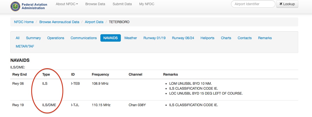
- TEB.jpg (100.96 KiB) Viewed 5101 times
Regards:
Cristian
Re: Question about KNYL ILS or LOC 21R
Posted: Fri Aug 22, 2014 10:17 am
by kullery
AHHH, Thanks Cristian.....
Yes, I saw "DME" in the heading and I assumed (always dangerous) that it applied to all entries in that section.
Re: Question about KNYL ILS or LOC 21R
Posted: Sun Aug 24, 2014 10:40 pm
by HRutila
ccapilot wrote:I think that you are confusing the title with the navaid type... the navaid type is ILS, that means without DME...
That's not quite correct. The ILS may still have DME, but if the approach title is ILS/DME, it means the ability to receive DME is required to fly the approach. Some ILSs have DME but do not require aircraft flying the approach to be able to receive it. For example, Denver (DEN) has a localizer with DME installed on Runway 7, and DME distances are published on the ILS or LOC RWY 7 chart, but because the approach is not named ILS/DME or LOC/DME RWY 7 (or any combo therein), and "DME REQUIRED" does not appear in the notes or on the plan view, an aircraft does not need to have DME capabilities to fly that approach.