Page 1 of 2
kase missed app
Posted: Sat Apr 25, 2015 6:18 am
by falopz
Hi
published missed kase depict climb to 14.oooft turn right heading 300 to intercept bc localizer....to LYNDZ..
not doing a tight turn, i find that localizar if i fly 300 heading i tend to flight paralell to it....
its legal not to fly 300 and fly 280 or 290 to intercept it, or you must fly 300....and maybe it wont be intercepted..
there are big mountainn around....
luis
Re: kase missed app
Posted: Sat Apr 25, 2015 7:20 am
by Marcus Becker
If you fly the missed approach as published, you will not hit a mountain. If you fly your own version of a missed approach, you might hit a mountain.
Re: kase missed app
Posted: Sat Apr 25, 2015 7:28 am
by kullery
Hi Luis,
In the image below (from Foreflight) you can see that MAFMU is located 2.9 NM from the I-PKN 303 degree radial. Even at 180KT with a 30 degree bank angle, the turning radius is 4992 ft. A turn to a heading of 300 degrees which is initiated at MAFMU should be complete before reaching the 303 degree radial.
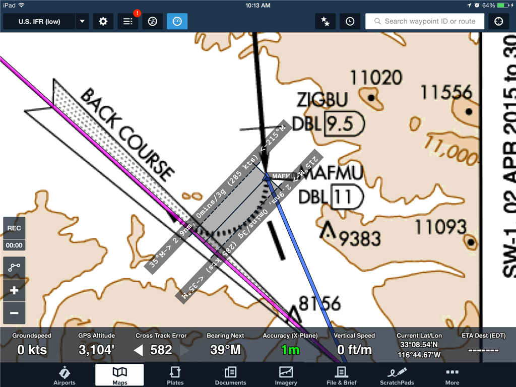
- IMG_0007.PNG (470.23 KiB) Viewed 7047 times
Re: kase missed app
Posted: Sat Apr 25, 2015 8:30 am
by Keith Smith
Ken, your point proves what the OP is saying...the turn WILL be completed PRIOR to joining the localizer. Now you're left with a 3 degree intercept in no wind conditions. With west winds being prevalent in the area, it's very likely that if you fly a 300 heading (not track), you will remain east of the localizer and actually get further and further away.
The text of the missed says to use a 300 heading AND the localizer (as opposed to a 300 heading to JOIN the localizer). I'd fly it as a 300 heading initially, then take stock of my current location (based on the CDI deflection and any GPS sources) and fly a 270-280 TRACK to join that localizer. The text isn't specific about a specific heading to intercept the localizer, so it seems some common sense is required on this one.
PG, I'd love to hear your take on this one. I've seen plenty of missed approaches that say to proceed via a heading AND a specific course based on a navaid but haven't put much thought into the implications of that. It seems like it's reasonable to fly the heading then take the necessary action to intercept the next course.
Re: kase missed app
Posted: Sat Apr 25, 2015 9:34 am
by kullery
Keith Smith wrote:Ken, your point proves what the OP is saying
Duhhh.....yup, I wasn't awake on this one. I got into my head that Luis was afraid of ending up WEST of the localizer.
Re: kase missed app
Posted: Sat Apr 25, 2015 11:44 am
by falopz
ken its just the opposite ive flown this twice and maybe im doing a tight turn or slower speed, i normally end parallel to the loclizer...
ive mentioned the mountains just to be aware that with 280 heading aprox you will be heading towards the mountains...
thanks a lot
Luis
Re: kase missed app
Posted: Sat Apr 25, 2015 11:57 am
by falopz
just noticed another thing im flying the approach locdme chart from skyvector, missed ( CEYAG) is 4 miles (pretty far from runway)....so the turn i think with 30 degres it has to be less than 30 degrees.
luis
Re: kase missed app
Posted: Sat Apr 25, 2015 12:24 pm
by kullery
I wouldn't worry if the turn ends up exactly on the localizer. As Keith said, I would make an initial turn to heading of 300 and get the climb established. Then evaluate my position relative to the I-PKN localizer and adjust as necessary to track the I-PKN back course. Possibly the initial 300 degree heading is to insure that you are intercepting the localizer from the northeast side which is away from the neaest mountains?
Ultimately it is the localizer and altitude (not a specific heading) that will keep you off of the mountains.
Re: kase missed app
Posted: Sat Apr 25, 2015 7:00 pm
by Peter Grey
Ahh the good old ASE missed approach, the single most confusing missed in the country...
The question is 100% valid, a heading of 300 won't result in an intercept of the localizer in any case where the crosswind is greater then about 5% of the TAS of the aircraft (and from the West obviously). In a C172 this is going to be around 15 knots which around ASE is quite common I imagine. So what gives?
Well believe it or not the answer is "it doesn't matter". Yes that's right, doesn't matter if you intercept or not.
Now let's answer why:
Assumptions: You climb at 200 ft/nm, have started the missed approach at the MAP and MDA and turn at standard rate.
Depending on wind you may or may not intercept the localizer after the turn.
Obvious case 1: You intercept the localizer. On the localizer you have guarantee obstruction clearance up to 700' off course at the localizer antenna, expanding out to 1 NM at 50,000 ft (8.22 NM), this continues to expand out as you go further out. Looking at the chart we can all agree that as long as you don't cross well west of the localizer you won't hit anything.
Not so obvious case 2: You fly heading 300 and never intercept the localizer or even worse diverge from it, now what? First off the fact you never hit the localizer has no bearing on your ability to fly the missed approach. On heading 300 you eventually hit the DBL 244 radial and fly it outbound to GLENO. You can do that without ever touching the localizer.
Well for a missed approach without positive course guidance you must have a 15 degree wide buffer on each side of the "heading". Well wait I don't know where I'm going to end up after the turn so 15 degrees from where?
The answer is 15 degrees from every possible point you could roll out (from a crazy tight turn to a standard rate turn at the max speed for the categories of aircraft that could do the approach). So this is a Cat A-C approach so the assumed radius of turn is from 1.3 to 3 NM. The math is a bit hard to go through via text so let's just say the "safe area" after the turn would be from the I-ASE locazlier to a point 6 NM SW of the I-ASE localizer (which is actually well past the I-PKN localizer).
So you take these 2 points (the I-ASE localizer) and that point 6 NM west and draw 2 lines, from the I-ASE localizer a line on heading 315 (which remains West of I-ASE at all times), and from the point 6NM West a line on heading 285.
So the 315 line won't hit anything (there is nothing to hit between the localizers), however a 285 heading from that point 6NM West will hit the 12953' mountain shown on the chart well West of I-PKN. If you climbed at 200 ft/nm you would be at 12640' at this point, thats a couple hundred feet below the mountain (this is bad). Note this mountain is about 6 NM West of the I=PKN localizer.
So the 285 heading (allowing for 15 degree drift off that 300 heading) after a nice wide turn won't work, so we need some way to prevent the aircraft from drifting too far West, hence the installation of I-PKN.
So the purpose of I-PKN isn't to be the missed approach course, it's designed to be the "west boundary" to prevent you from drifting into a mountain while on heading 300.
Or in the other words, the purpose of the heading isn't to get you on the localizer, it's the other way around, the purpose of the localizer is to prevent you from getting off heading.
So on the missed fly heading 300, if you hit the localizer fly that, if you don't just intercept the DBL-244 outbound. No need to "force" the intercept.
That's all there is to it, let me know if you have any questions.
Re: kase missed app
Posted: Sat Apr 25, 2015 7:10 pm
by Nelson L.
That is an outstanding and very complicated answer (educational as well) - had to read it over quite a few times..... Thanks for the time Peter!
Quick question, if you were to say, have a flap overspeed or part of a wing fall off (this is theoretical by the way...) and can't make a standard rate turn, are you obliged to notify ATC for vectors due to the "complicated math that can't be explained on text" thing not providing terrain and obstruction clearance? Also, how is a "crazy tight turn" calculated? 90 degrees bank and full elevator?
